
Escaping the Crowds: Hiking Sri Pada (Adam's Peak) via Uda Maliboda
An unvarnished and immersive journey to the holy summit via Sri Lanka's most remote path

Adam's Peak, also known by locals as "Sripadaya," is the most sacred mountain in Sri Lanka. Standing 2,243m (7,359 ft) tall above sea level, this mountain is revered by all faiths in Sri Lanka. The Buddhists believe Lord Buddha's footprint is placed atop a rock on the top of the mountain. Therefore, thousands of Buddhist pilgrims flock to this holy mountain every year to worship lord buddha's sacred footprint.
Where is Sripada located?
Sripada, aka Adam's Peak, is located in the Sabaragamuwa province of Sri Lanka. It is engulfed within the peak wilderness sanctuary covering a large area of untouched jungle.
When is the Sripada season?
Sripada season falls from December to April every year. This coincides with the best time to travel in Sri Lanka, where the west coast is dry. Many foreign visitors to Sri Lanka endeavor to climb Adam's Peak at this time.
What are the main routes to climb Sripada?
There are 03 main routes and 03 less traveled trails to reach the top of Adam's Peak. Additionally, there are 02 more trails which are suitable for the extremely adventurous.
The main 3 routes to the Sripada are as follows:
- Hatton - Nallathanniya route
- Ratnapura - Palabaddalla route
- Kuruwita - Erathna route
The less-traveled jungle trails are as follows:
- Rajamale - Sandagalatenna trail
- Deraniyagala - Uda-maliboda trail
- Dehenakanda - Mukkuwatta trail
The following routes are lesser-known jungle treks that are advanced and treacherous.
- Baththulu Oya - Waterfalls trail
- Baththulu Oya - Paradise Falls Trail
To summarize, the easiest and most popular route is the Hatton - Nallathanniya, which is one of the shortest and well-known amongst the locals and the foreign travelers due to its length (only 5km) and ease of access.
Kuruwita - Erathna and Ratnapura - Palabaddala routes are lesser known among foreigners due to the fact that both start in the Ratnapura area, which is not situated along the well-travelled tourist trails. But you can expect a decent local crowd in both of these trails during the season. Both of these trails have lights to ease the pilgrims who travel by night.
The Jungle Trails
The remaining trails all lie within the peak wilderness sanctuary. A thick, untouched mountain forest that provided pilgrims/hikers with a serene experience. A few mini-rivers are flowing within this sanctuary, which makes it more blissful.
Out of the jungle trails, the easiest and shortest is the Rajamale trail, which spans about 5 km within the sanctuary.
The Dehenakanda - Mukkuwatta trail is the most difficult out of these 3 due to its length and the terrain. There is no proper documentation as to the correct length of this trail, but it can be roughly ascertained to be 14km of tough climb. It takes 2 days to reach the holy mountain via this trail, and the pilgrims/hikers need to camp overnight within the jungle by the Paradise Falls.
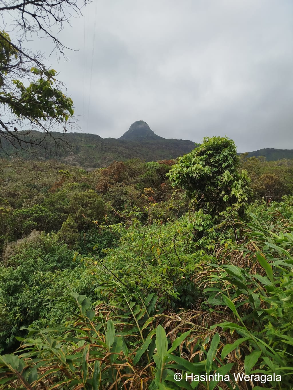
The remaining trail, which I'm going to discuss in detail, is the Deraniyagala - Uda Maliboda. I happened to venture via this trail recently and thought of documenting it while the experience is fresh in my mind.
How to get to the trail head of Deraniyagala - Uda Maliboda trail?
The trail starts at a sleepy village called Dikellakanda. To reach this, you have to first reach a town called Awissawella, where you can catch the first bus to Deraniyagala at 5.00 am. Upon reaching Deraniyagala, you can catch the first bus to Uda-Maliboda at 06.30 am. You have to get off this bus at Uda Maliboda tea factory, where you can arrange a three-wheeler to get you to the trailhead at Dikellakanda.
The state of this 6-7 km stretch is in a dire situation, and only a vehicle with high ground clearance can drive on it. Although you can walk this distance, it is not recommended because you have to save energy and time for the jungle trail. It is advisable to get out of the jungle trail before it gets dark.
The summary of the route as follows from Colombo.
Colombo to Avissawella (45.5 km) -> Avissawella to Deraniyagala (22.3 km) -> Deraniyagala to Uda-Maliboda Tea factory (15 km) -> Uda - Maliboda Tea factory to Dikellakanda (6 km)
The Beginning of the Trail
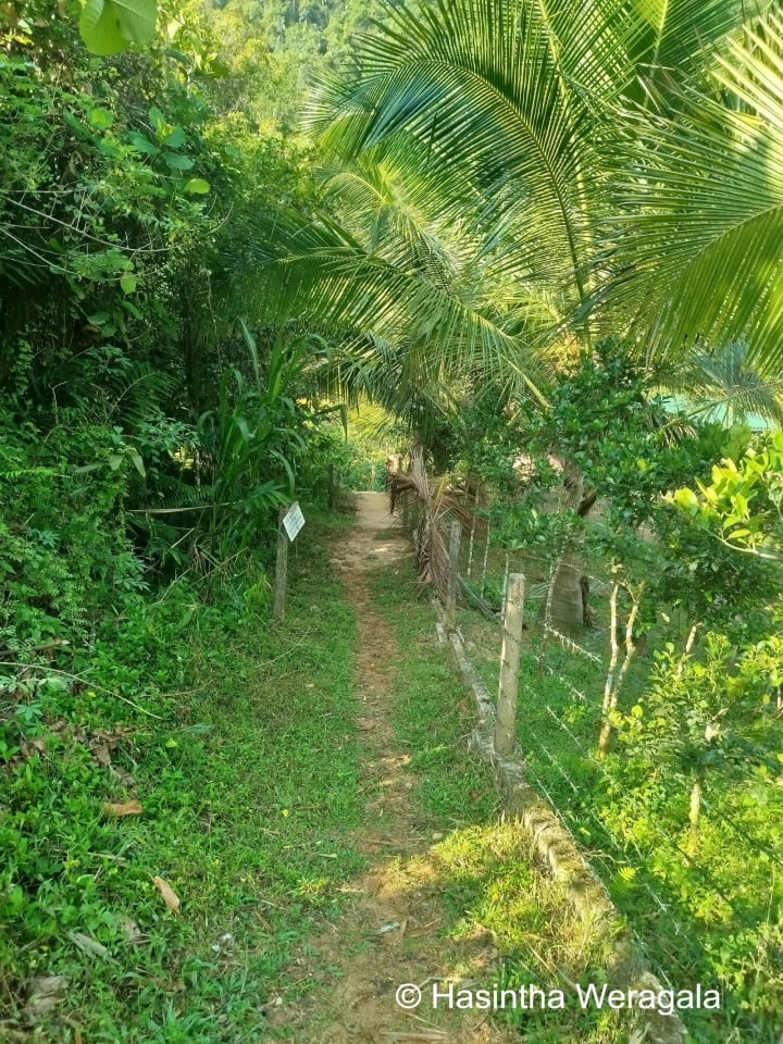
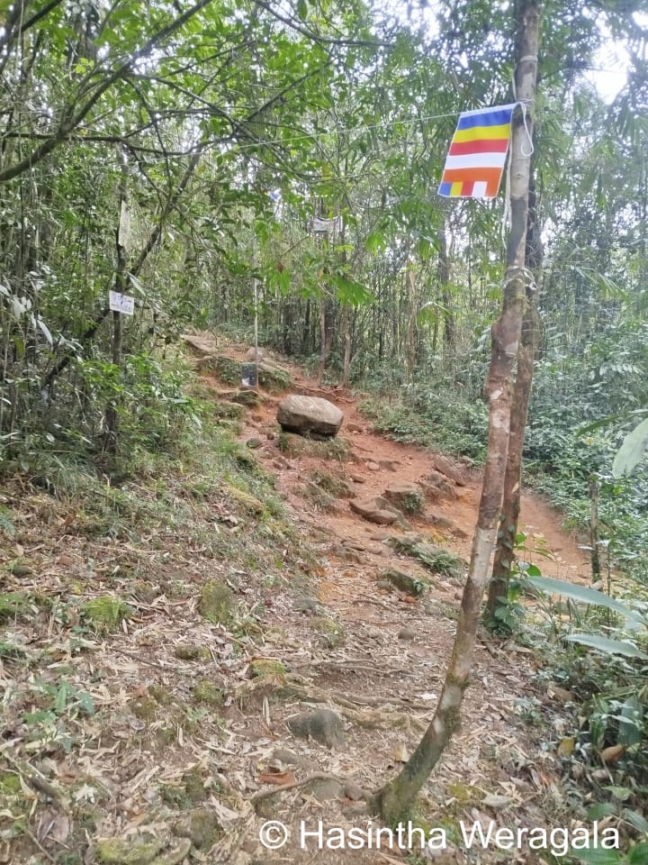
The trail starts with a clearly marked signpost. The initial footpath, as shown above, leads to a small shrine dedicated to the Deity of Saman. Just past this shrine lies the Pandeniya River, which you have to cross to get to the trail.
Initially, the trail moves parallel to the river and gradually diverges from it to a steep slope. The path is clearly visible, and from time to time, you can see there are Buddhist flags hung above the trail, which confirms that you are on the right track.
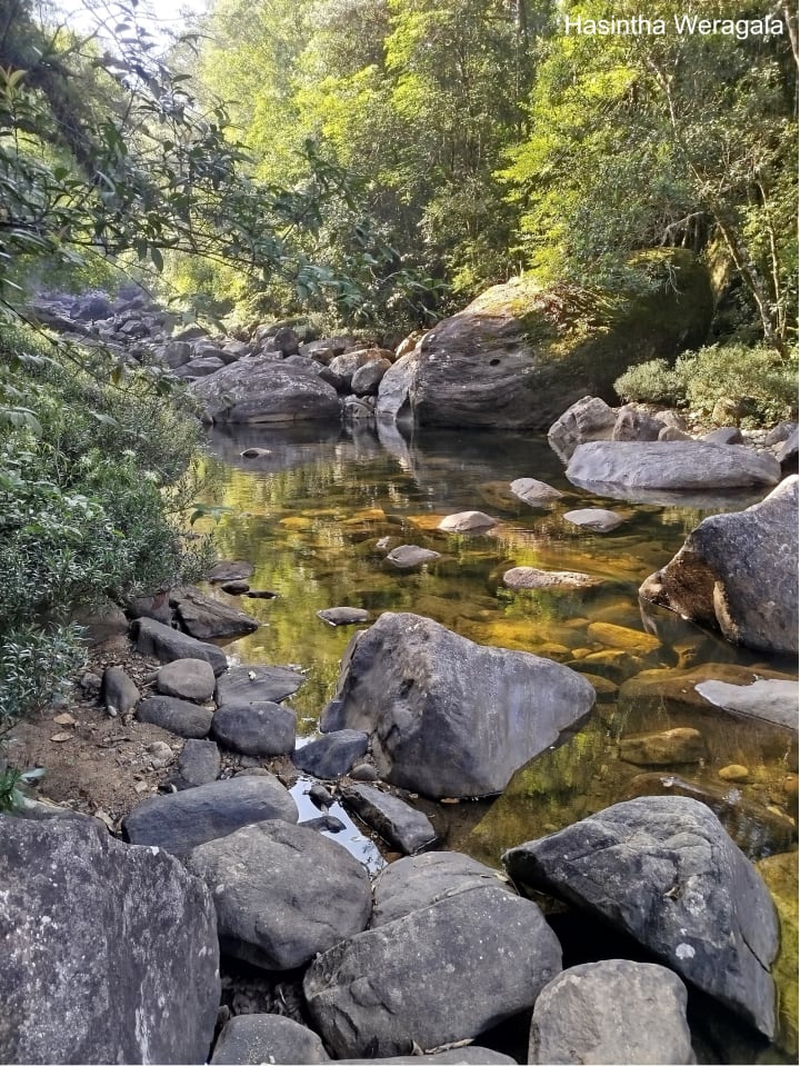
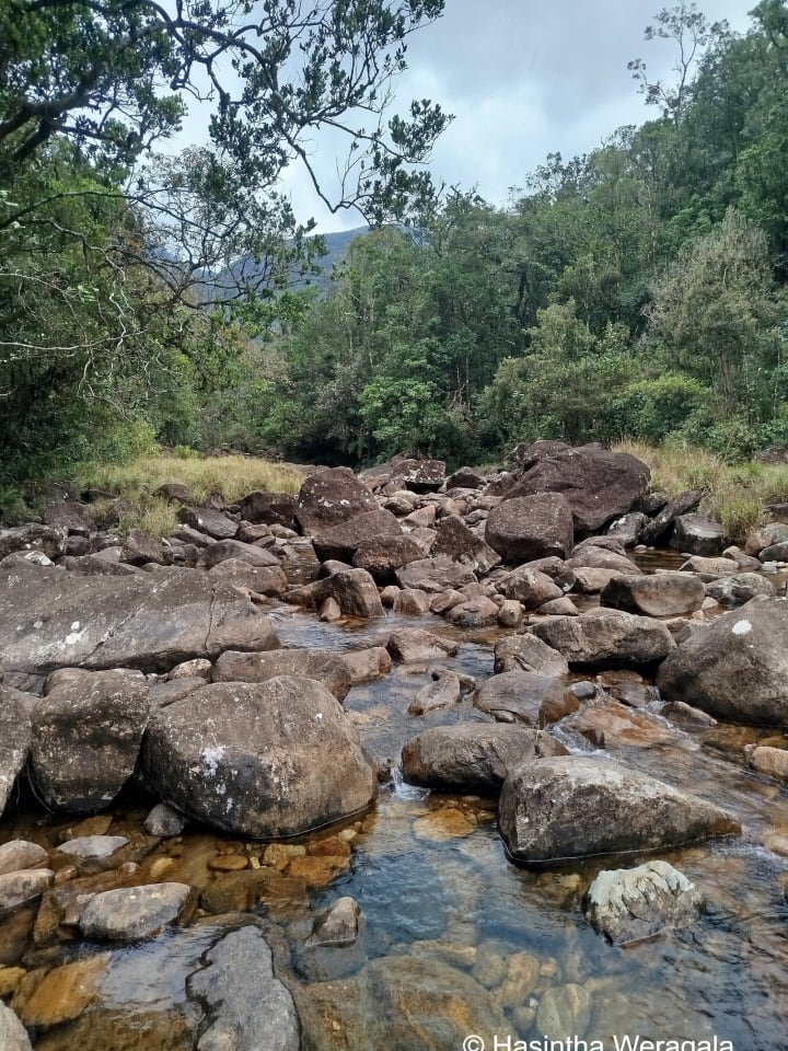
The continuous climb continues until you reach a serene stream called Maha Oya. A good resting place to replenish your strength and rejuvenate after a hectic climb.
The trail continues thereafter with a mix of flat sections and the upward climb. Roots of trees adorn the trail and make it difficult to tread. If you're visiting in the rainy season (off-season), make sure to equip yourself with leech socks.
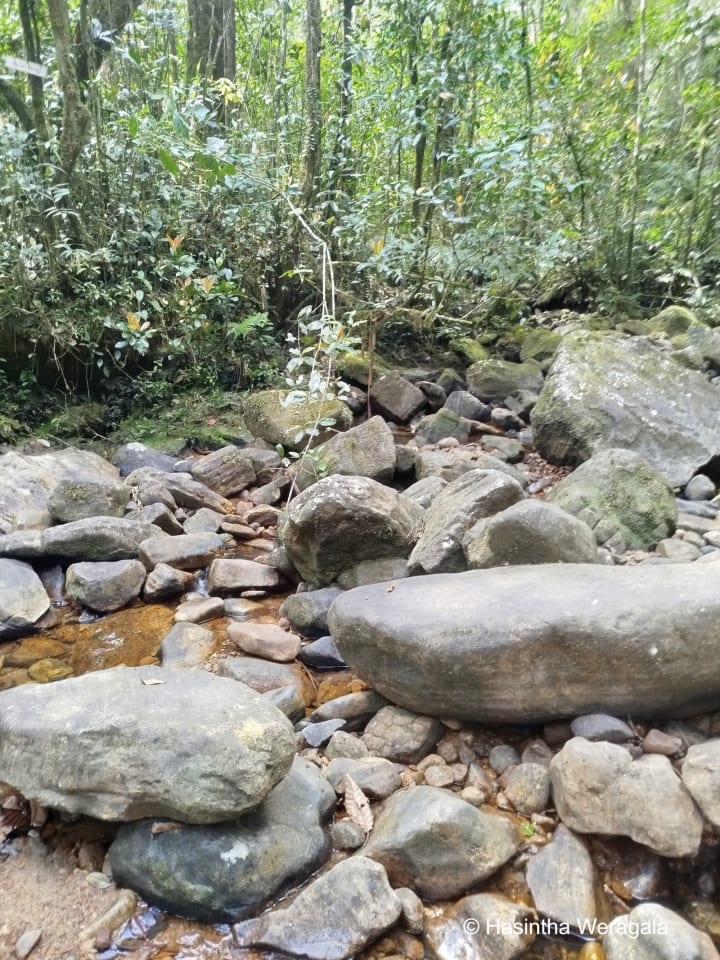
Around 3km from the trail head, as the sound of the river completely disappears in the distance, you will encounter a section of steep ascent. The trail will cross many streams along the way, so there is no need to carry a lot of water with you. But make sure to stay hydrated using "Jeewani" because you'll sweat a lot due to the humidity.
After a few hours of walking inside the forest, you'll reach a gradual descent that points the trail to the "Kuru River" valley. This is a main milestone of this trail. If you've reached this point, you have conquered much of the trail.
The trail continues from about 25m upstream (to your left). This location is marked with Buddhist flags, so it is hard to miss. The trail continues parallel to the river for some time and moves away gradually. This part is a continuous ascent through thick-rooted trail until you reach a flat section that directly connects to the Kuruwita - Erathna Trail. This location is called Madahinna.
Once you reach this point, you'll have travelled 8 km within the jungle. From this point, the route is very prominent, and you'll find many pilgrims and resting places up to the holy mountain. The rest of 1km is a continuous climb through boulders up to a resting place (Ambalama) called "Galwangediya". Beyond this point, it is a continuous climb up stairs to the top of the Adams Peak. In "Galwangediya," you'll see a route join from the right. This is Ratnapura - Palabaddala road, aka "Raja Mawatha" (King's road).
I hope you gained some insight on this route and someday enjoy this hike through the lush greenery of the peak wilderness sanctuary.
What are the risks involved with this trail?
If you're travelling in the off-season, there is a high chance that you will encounter rain. The rain brings out leeches. So wear a proper leech sock to alleviate them.
The other risk is a viper called "Kunakatuwa." Wikipedia describes this viper as follows.
Hypnale hypnale is a venomous pit viper species endemic to India and Sri Lanka. Common names include the hump-nosed viper, Merrem's hump-nosed viper, hump-nosed pit viper, and Oriental hump-nosed viper. No subspecies are currently recognized.
These vipers hardly pose a threat during the day, for they love to snuggle in cold and damp shadows. But at nighttime, they go after their prey. So it is of paramount importance to get out of the forest area before it gets dark.
"Kunakatuwa" is highly venomous, and its bite is extremely painful and can cause blindness. It must be treated by a doctor as soon as possible.
About the Creator
Hasintha Weragala
Travel writer with a deep passion for Sri Lanka. I explore the island’s hidden gems, iconic destinations, and local culture — sharing stories, travel tips, and insights to help you experience Sri Lanka beyond the guidebook.
Keep reading
More stories from Hasintha Weragala and writers in Wander and other communities.
The "Alternate Route" Guide: Navigating the 2026 Sri Lanka Transit Shift
For the first two months of 2026, Sri Lanka was the undisputed darling of the global travel scene. The island shattered arrival records, welcoming over 550,000 visitors who flocked to our shores for the T20 World Cup and the blooming hills of the tea country. But as of early March, the "aerial bridge" through the Gulf—the massive transit corridor through Dubai, Doha, and Abu Dhabi that typically carries over a third of our island’s tourists—effectively shifted into a complex logistical puzzle due to regional airspace closures.
By Hasintha Weragala26 days ago in Wander
Worth the Wait: Puerto Viejo, Costa Rica
Beach bumming in a small Caribbean beach town sounded like a perfect way to end our 6-month trip through Mexico and Central America. Or so we thought. The foul, fishy stench of rotten seaweed hit our nostrils as we stepped from the cramped bus and looked out at a rather depressing, empty, and underwhelming black sand beach. It was pouring with rain, and we had to quickly fish out our ponchos. We thought, this couldn’t be it, could it?
By Sh*t Happens - Lost Girl Travel28 days ago in Wander


Comments (1)
If you need contact details of a three-wheel guy or mini truck driver to reach the trailhead from the Maliboda tea factory, please let me know in the comments.