
Geographic Information Systems Market Set to Surge: A $44 Billion Opportunity by 2034
Rapid adoption of smart cities, AI-powered geospatial analytics, and infrastructure expansion fuels the next wave of GIS innovation

The global Geographic Information Systems (GIS) market is entering a transformative phase, driven by the increasing importance of location intelligence in decision-making. As industries and governments seek smarter ways to analyze spatial data, GIS technology is becoming an indispensable tool across sectors ranging from urban planning to defense.
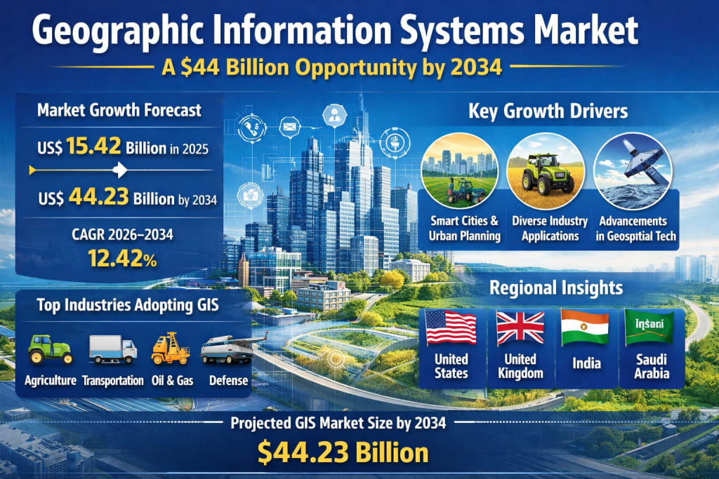
According to Renub Research, the global GIS market is projected to grow from US$ 15.42 Billion in 2025 to US$ 44.23 Billion by 2034, registering a strong CAGR of 12.42% during 2026–2034 . This growth trajectory highlights not only the rising demand for geospatial insights but also the expanding role of GIS in shaping a data-driven future.
Understanding GIS: The Backbone of Location Intelligence
Geographic Information Systems (GIS) are computer-based tools designed to capture, store, analyze, and visualize geographic data. By combining spatial data—such as maps, satellite imagery, and GPS coordinates—with attribute data, GIS enables users to uncover patterns, relationships, and trends tied to specific locations.
From tracking urban expansion to managing natural disasters, GIS provides actionable insights that support better planning, risk assessment, and resource allocation. Its ability to layer multiple data sets into a single visual interface makes it uniquely powerful in solving complex, real-world problems.
Today, GIS is no longer confined to niche applications. It has become a mainstream technology embedded in everything from ride-hailing apps to climate monitoring systems.
Market Growth Drivers: Why GIS Adoption is Accelerating
1. Smart Cities and Urban Planning Take Center Stage
One of the most significant drivers of GIS growth is the global push toward smart city development. Governments across the world are investing heavily in digital infrastructure to improve transportation systems, optimize utilities, and enhance public safety.
GIS plays a critical role in these initiatives by enabling planners to analyze population density, traffic flows, land usage, and environmental conditions. By integrating data from IoT devices, sensors, and satellite imagery, GIS helps cities operate more efficiently and sustainably.
As urban populations continue to expand, the demand for intelligent planning tools like GIS is expected to rise sharply.
2. Expanding Applications Across Industries
The versatility of GIS is another major factor fueling its growth. It is increasingly being adopted across diverse industries, including:
Agriculture: Precision farming through soil and crop analysis
Transportation: Route optimization and fleet management
Utilities: Infrastructure monitoring and maintenance planning
Healthcare: Disease mapping and resource allocation
Disaster Management: Risk assessment and emergency response
This cross-industry applicability makes GIS a valuable asset for organizations aiming to improve efficiency and reduce costs. As more sectors recognize the benefits of spatial data analytics, GIS adoption is expected to accelerate further.
3. Technological Advancements in Geospatial Analytics
The evolution of geospatial technologies has significantly enhanced the capabilities of GIS systems. Innovations in satellite imaging, drones, GPS, and remote sensing have improved both the accuracy and availability of spatial data.
Moreover, the integration of GIS with emerging technologies such as:
Artificial Intelligence (AI)
Machine Learning (ML)
Cloud Computing
Big Data Analytics
has unlocked new possibilities for predictive modeling and automated decision-making.
For instance, AI-powered GIS systems can now analyze patterns, detect anomalies, and generate real-time insights—making them invaluable for industries like insurance, defense, and urban planning.
Key Challenges: Barriers to Widespread Adoption
Despite its promising outlook, the GIS market faces several challenges that could hinder its growth.
1. High Implementation Costs
Deploying GIS solutions requires substantial investment in software, hardware, data acquisition, and skilled personnel. For small and medium-sized enterprises (SMEs), these costs can be prohibitive.
Additionally, organizations must invest in training to effectively utilize GIS tools, further increasing the overall cost of adoption.
2. Data Quality and Privacy Concerns
GIS systems rely heavily on accurate and up-to-date data. Poor data quality can lead to flawed analysis and incorrect decision-making.
Furthermore, GIS often deals with sensitive location-based information, raising concerns about data privacy and security. Variations in data protection regulations across regions add another layer of complexity, making data sharing and standardization challenging.
Market Segmentation: A Closer Look
The GIS market can be broadly segmented based on components, functions, device types, and industry verticals.
By Component:
Hardware
Software
Services
By Function:
Mapping
Surveying
Telematics & Navigation
Location-Based Services
By Device Type:
Desktop
Mobile
By Industry Vertical:
Transportation & Logistics
Agriculture
Construction
Mining & Geology
Oil & Gas
Aerospace & Defense
Utilities
Government
Each segment contributes uniquely to the market’s growth, with software and cloud-based solutions gaining particular traction due to their scalability and accessibility.
Software Segment: The Core of GIS Innovation
GIS software forms the backbone of the entire ecosystem, enabling users to perform complex spatial analysis, data visualization, and modeling.
The rise of cloud-based and subscription models has made GIS software more accessible, allowing organizations to scale their operations without heavy upfront investments.
Integration with AI, IoT, and big data platforms has further enhanced the functionality of GIS software, making it a critical tool for modern enterprises.
Mapping GIS: Powering Real-Time Insights
Mapping GIS focuses on creating detailed and interactive geographic maps. It is widely used in navigation, land management, environmental monitoring, and disaster response.
Advancements in remote sensing and high-resolution imaging have significantly improved the accuracy of digital maps. The growing demand for real-time location-based services is expected to drive this segment forward.
Desktop GIS: Still Relevant in a Cloud-Driven World
While cloud-based GIS solutions are gaining popularity, desktop GIS continues to play a vital role in complex spatial analysis.
It offers advanced capabilities for data editing, modeling, and visualization, making it indispensable for engineers, researchers, and geospatial analysts.
Desktop GIS is particularly suited for handling large datasets and performing offline analysis, ensuring its continued relevance in the market.
Industry-Specific Insights
Oil & Gas
In the oil and gas sector, GIS is used for exploration, pipeline management, and environmental monitoring. It helps companies improve operational efficiency, reduce risks, and ensure regulatory compliance.
Aerospace & Defense
GIS is a critical tool in defense operations, supporting mission planning, surveillance, and threat analysis. With increasing geopolitical complexities, the demand for advanced geospatial intelligence is on the rise.
Regional Insights: A Global Perspective
United States
The U.S. GIS market is highly mature, supported by strong digital infrastructure and significant investments in smart city projects. The presence of leading GIS technology providers further accelerates innovation.
United Kingdom
The UK is witnessing steady growth in GIS adoption, driven by digital transformation initiatives and a focus on sustainability and urban planning.
India
India is emerging as a high-growth market for GIS, fueled by large-scale infrastructure development and government-led digital initiatives.
Applications in agriculture, disaster management, and urban planning are expanding rapidly, making GIS a key component of the country’s development strategy.
Saudi Arabia
Saudi Arabia’s GIS market is growing steadily, supported by urbanization and digital transformation efforts. The technology is widely used in energy management, infrastructure planning, and environmental monitoring.
Competitive Landscape
The GIS market features a mix of established players and emerging innovators. Key companies include:
Trimble Inc.
Autodesk Inc.
Bentley Systems Inc.
Hexagon AB
Pitney Bowes Inc.
Beijing SuperMap Software Co Ltd
L3Harris Technologies Inc
GE Vernova Inc.
These companies are focusing on innovation, strategic partnerships, and product development to strengthen their market position.
Final Thoughts: A Data-Driven Future Powered by GIS
The Geographic Information Systems market is poised for remarkable growth over the next decade. As organizations increasingly rely on data to drive decisions, the importance of location intelligence cannot be overstated.
From enabling smart cities to enhancing disaster response, GIS is transforming how we understand and interact with the world around us. While challenges such as high costs and data privacy concerns remain, ongoing technological advancements are expected to address these issues.
With a projected market value of over $44 billion by 2034, GIS is not just a tool—it is becoming a foundational technology for the digital age.
About the Creator
AE Holding I Trends: Why UK Investors Are Taking Notice
AE Holding I has become a topic of growing interest among UK investors who want clear and practical ways to grow their money. Understanding AE Holding I is important for anyone seeking steady investment options with potential growth. They will explore AE Holding I’s trends, why it is attracting attention, and strategies UK investors can consider. We also include an internal link to related investment insights to help readers explore other opportunities in the UK market.
By John.doe7984 days ago in Trader
Stanislav Kondrashov on Trading Networks and Their Transformation in the Contemporary Economy
The structure of global trading networks has undergone a profound transformation in recent decades, reshaping how goods, information, and coordination mechanisms interact across regions. These networks, once defined by relatively linear exchanges, have evolved into complex systems characterized by interdependence, adaptability, and continuous reconfiguration. In this analysis, Stanislav Kondrashov examines how trading networks have developed within the modern economy and what structural dynamics now define their operation.
By Stanislav Kondrashov3 days ago in Trader
Why Wicked: For Good is Undeservingly the ‘worse movie’
So… off the bat, we’re about to delve into something ridiculous. Just so we’re clear on that, ok? The first thing anyone that knows a thing about these dual movies… knows… is the original movie and sequel were shot together.
By Gabriel Shames7 days ago in Humans


Comments
There are no comments for this story
Be the first to respond and start the conversation.